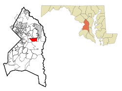
Kettering, Maryland | |
|---|---|
 Location of Kettering, Maryland | |
| Coordinates: 38°53′42″N 76°47′47″W / 38.89500°N 76.79639°W | |
| Country | |
| State | |
| County | |
| Area | |
• Total | 5.51 sq mi (14.28 km2) |
| • Land | 5.49 sq mi (14.23 km2) |
| • Water | 0.02 sq mi (0.05 km2) |
| Elevation | 138 ft (42 m) |
| Population (2020) | |
• Total | 14,424 |
| • Density | 2,625.89/sq mi (1,013.79/km2) |
| Time zone | UTC−5 (Eastern (EST)) |
| • Summer (DST) | UTC−4 (EDT) |
| ZIP codes | 20774-20775 |
| Area code(s) | 301, 240 |
| FIPS code | 24-43900 |
| GNIS feature ID | 1714445 |
Kettering is an unincorporated area and census-designated place in Prince George's County, Maryland, United States.[2] At the 2020 United States Census, the population was 14,424,.[3] Kettering is adjacent to Prince George's Community College, the upscale gated community of Woodmore, Six Flags America, Evangel Temple megachurch, and the community of Largo at the end of the Washington Metro Blue Line. Watkins Regional Park in Kettering offers a large playground, a colorful carousel, miniature golf, a miniature train ride, and various animals.
- ^ "2020 U.S. Gazetteer Files". United States Census Bureau. Retrieved April 26, 2022.
- ^ U.S. Geological Survey Geographic Names Information System: Kettering, Maryland
- ^ "Kettering CDP, Maryland". United States Census Bureau. Retrieved April 15, 2022.