Kettleman City | |
|---|---|
 Kettleman City in 2008 | |
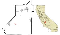
 Location in Kings County and the state of California | |
| Coordinates: 36°00′30″N 119°57′42″W / 36.00833°N 119.96167°W | |
| Country | United States |
| State | |
| County | |
| Area | |
| • Total | 0.211 sq mi (0.546 km2) |
| • Land | 0.211 sq mi (0.546 km2) |
| • Water | 0.000 sq mi (0.000 km2) |
| Elevation | 253 ft (77 m) |
| Population | |
| • Total | 1,242 |
| • Density | 5,900/sq mi (2,300/km2) |
| Time zone | UTC-8 (PST) |
| • Summer (DST) | UTC-7 (PDT) |
| ZIP code | 93239 |
| Area code | 559 |
| FIPS code | 06-38394 |
| GNIS feature ID | 1652733 |
Kettleman City is a census-designated place (CDP) in Kings County, California, United States. Kettleman City is located 28 miles (45 km) southwest of Hanford,[4] 54 miles (88 km) south of Fresno, at an elevation of 253 feet (77 m),[2] and sits only about 1/2 mile north of the 36th parallel north latitude. It is part of the Hanford-Corcoran Metropolitan Statistical Area. The population was 1,242 at the 2020 census,[3] down from 1,439 at the 2010 census. When travelling between Los Angeles and either San Francisco or Sacramento via Interstate 5, Kettleman City (at Exit 309) is near the halfway point, and is thus a major stopping point for food and lodging.
- ^ "2021 U.S. Gazetteer Files". United States Census Bureau. Retrieved February 27, 2023.
- ^ a b U.S. Geological Survey Geographic Names Information System: Kettleman City, California
- ^ a b "Explore Census Data". United States Census Bureau. Retrieved February 27, 2023.
- ^ Durham, David L. (1998). California's Geographic Names: A Gazetteer of Historic and Modern Names of the State. Clovis, Calif.: Word Dancer Press. p. 1056. ISBN 1-884995-14-4.