Russey Keo
ឫស្សីកែវ | |
|---|---|
| Russey Keo District Khan Russey Keo ខណ្ឌឫស្សីកែវ | |
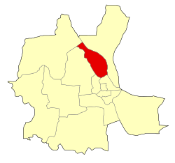
 Location of Russey Keo within Phnom Penh | |
| Coordinates: 11°37′10″N 104°54′36″E / 11.61946°N 104.9099°E | |
| Country | |
| Province | Phnom Penh |
| Area | |
| • Total | 23.3 km2 (9.0 sq mi) |
| Population (2019)[1] | |
| • Total | 274,861 |
| Time zone | UTC+7 (ICT) |
| Postal code | 12100 |
| Geocode | 1207 |
Russey Keo (Khmer: ប្ញស្សីកែវ [ʔrɨhsəj kaew]; meaning "Crystal Bamboo"), also spelled as Russei Keo, is a district (khan) in Phnom Penh, Cambodia. This district consists of the northern and north-eastern outskirts of the main city of Phnom Penh, stretching from Khan Sen Sok in the west to the Tonlé Sap River in the east. As of 2019, it is the most populous district of Phnom Penh.
- ^ "General Population Census of the Kingdom of Cambodia 2019 – Final Results" (PDF). National Institute of Statistics. Ministry of Planning. 26 January 2021. Retrieved 3 February 2021.
