This article needs additional citations for verification. (March 2019) |
Khartoum State
ولاية الخرطوم Wilāyat al-Kharṭūm | |
|---|---|
 | |
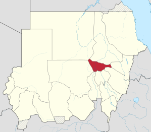
 Location in Sudan. | |
| Coordinates: 15°47′N 32°43′E / 15.783°N 32.717°E | |
| Country | |
| Capital | Khartoum |
| Area | |
• Total | 22,142 km2 (8,549 sq mi) |
| Population (2018 est.[1]) | |
• Total | 7,993,900 |
| • Density | 360/km2 (940/sq mi) |
| Central Bureau of Statistics Sudan (web) | |
| Time zone | UTC+2 (CAT) |
| ISO 3166-2 | SD-KH |
| HDI (2017) | 0.625[2] medium · 1st |
| Website | http://krt.gov.sd http://khartoum.gov.sd/ |
Khartoum State (Arabic: ولاية الخرطوم, romanized: Wilāyat al-Kharṭūm) is one of the eighteen states of Sudan. Although it is the smallest state by area (22,142 km2), it is the most populous state in Sudan - 5,274,321 in the 2008 census,[3][4] and officially estimated at 7,993,900 in 2018.[5] It contains the country's largest city by population, Omdurman, together with the cities of North Khartoum and Khartoum; the City of Khartoum is the capital of the state as well as the national capital of Sudan. The capital city contains offices of the state, governmental and non-governmental organizations, cultural institutions, and the main airport.
The city is located in the heart of Sudan at the confluence of the White Nile and the Blue Nile, where the two rivers unite to form the River Nile. The confluence of the two rivers creates a unique effect. As they join, each river retains its own color: the White Nile with its bright whiteness and the Blue Nile with its alluvial brown color. These colors are more visible in the flood season.
The state lies between longitudes 31.5 to 34°E and latitudes 15 to 16°N. It is surrounded by River Nile State in the north-east, in the north-west by the Northern State, in the east and southeast by the states of Kassala, Qadarif, Gezira and White Nile State, and in the west by North Kurdufan.
- ^ "Pop. Proj. by satates" (PDF). Government of Sudan. Archived from the original (PDF) on 12 March 2017. Retrieved 20 November 2019.
- ^ "Sub-national HDI - Area Database - Global Data Lab". Hdi.globaldatalab.org. Retrieved 2018-09-13.
- ^ "Sudan". Geohive.com. 2008. Archived from the original on 2014-08-06. Retrieved 28 August 2014.
- ^ Cite error: The named reference
2008_censuswas invoked but never defined (see the help page). - ^ Central Bureau of Statistics Sudan (web)

