Khon San
คอนสาร | |
|---|---|
 View from the main intersection of Highway 12 in Khon San township towards the Phetchabun Mountains to the west | |
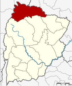
 District location in Chaiyaphum province | |
| Coordinates: 16°36′48″N 101°55′11″E / 16.61333°N 101.91972°E | |
| Country | Thailand |
| Province | Chaiyaphum |
| Seat | Khon San |
| Subdistrict | 8 |
| Muban | 85 |
| Area | |
• Total | 966.665 km2 (373.231 sq mi) |
| Population (2016) | |
• Total | 62,037 |
| • Density | 60.9/km2 (158/sq mi) |
| Time zone | UTC+7 (ICT) |
| Postal code | 36180 |
| Geocode | 3613 |
Khon San (Thai: คอนสาร, pronounced [kʰɔ̄ːn sǎːn]) is the northernmost district (amphoe) of Chaiyaphum province, northeastern Thailand.