Khotang District
खोटाङ जिल्ला | |
|---|---|
 View of Maratika-Halesi, a famous pilgrimage site | |
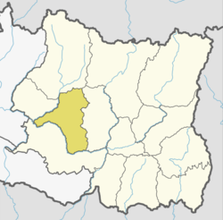
 Location of Khotang in dark yellow | |
 Khotang District with local level body | |
| Coordinates: 27°12′N 86°47′E / 27.200°N 86.783°E | |
| Country | |
| Province | Koshi Province |
| Established | 1962 |
| Admin HQ. | Diktel |
| Government | |
| • Type | Coordination committee |
| • Body | DCC, Khotang |
| • Deputy-Head | Mr. Iraj Khadka and Mrs. Pooja Khadka |
| • Parliamentary constituencies | 1 Ms Iruja Khadka |
| • Provincial constituencies | 2 |
| Area | |
• Total | 1,591 km2 (614 sq mi) |
| Population (2021) | |
• Total | 175,298 |
| • Density | 110/km2 (290/sq mi) |
| • Households | 42,647 |
| Demographics | |
| • Ethnic groups | Hindus, Kirat, Christians |
| • Ethnic castes | |
| • Female ♀ | 53 % |
| • Male ♂/100 female | 88.90 |
| Human Development Index | |
| • Income per capicta | 1,132 US$ |
| • Poverty rate | 29.47 |
| • Literacy | 69% |
| • Life Expectancy | 70.24% |
| Time zone | UTC+05:45 (NPT) |
| Postal Codes | 036 |
| Telephone Code | 56200 (List) |
| Main Language(s) | Nepali, Chamling , Magar, Tamang Language |
| Major highways | Pushpalal Highway, Sagarmatha Highway |
| Website | ddckhotang |
Khotang District (Nepali: खोटाङ जिल्ला) is one of 14 districts of Koshi Province of eastern Nepal. The district, with Diktel as its district headquarters, covers an area of 1,591 km2 (614 sq mi) and has a population (2021) of 206,312.[3] The district is bordered by Bhojpur District in the east, Udayapur District in the south, Okhaldhunga District in the west and Solukhumbu District in the North.[4] In this district there are two municipalities and eight rural/urban municipalities.
- ^ "NepalMap profile: Khotang".
- ^ "Nepal Human Development Report 2014".
- ^ Household and population by districts, Central Bureau of Statistics (CBS) Nepal Archived 2013-09-27 at the Wayback Machine
- ^ "Brief Introduction of Khotang District". Retrieved 20 January 2020.