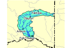
| Kiamichi River | |
|---|---|
 The Kiamichi River watershed | |
 | |
| Location | |
| Country | United States |
| State | Oklahoma |
| Physical characteristics | |
| Source | |
| • location | Polk County, Arkansas |
| • coordinates | 34°40′46″N 94°27′09″W / 34.6795487°N 94.4524425°W[2] |
| Mouth | |
• coordinates | 33°57′40″N 95°13′46″W / 33.96111°N 95.22944°W[2] |
• elevation | 114 m (374 ft) |
| Discharge | |
| • location | Antlers |
| • average | 1,615 cu ft/s (45.7 m3/s)[1] |
| Basin features | |
| River system | Red River |
The Kiamichi River is a river in southeastern Oklahoma, United States of America. A tributary of the Red River of the South, its headwaters rise on Pine Mountain in the Ouachita Mountains near the Arkansas border. From its source in Polk County, Arkansas, it flows approximately 177 miles (285 km)[3] to its confluence with the Red River at Hugo, Oklahoma.
- ^ "USGS Surface Water data for Oklahoma: USGS Surface-Water Annual Statistics".
- ^ a b U.S. Geological Survey Geographic Names Information System: Kiamichi River
- ^ U.S. Geological Survey. National Hydrography Dataset high-resolution flowline data. The National Map Archived 2012-03-29 at the Wayback Machine, accessed June 3, 2011