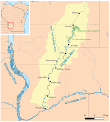
| Kickapoo River | |
|---|---|
 | |
 Kickapoo River watershed map | |
| Location | |
| Country | United States |
| State | Wisconsin |
| Region | Monroe County, Vernon County, Richland County, Crawford County |
| Physical characteristics | |
| Source | Midway between Wilton and Mill Bluff State Park |
| • location | Monroe County, Wisconsin, United States |
| • coordinates | 43°53′53″N 90°27′27″W / 43.89806°N 90.45750°W |
| • elevation | 1,200 ft (370 m) |
| Mouth | Confluence with the Wisconsin River |
• location | Wauzeka, Wisconsin, Crawford County, Wisconsin |
• coordinates | 43°04′36″N 90°52′59″W / 43.07667°N 90.88306°W[1] |
• elevation | 623 ft (190 m) |
| Basin features | |
| Tributaries | |
| • left | Billings Creek |
| • right | Moore Creek, Weister Creek, West Fork of the Kickapoo River, Reads Creek, Tainter Creek |
The Kickapoo River is a 126-mile-long (203 km)[2] tributary of the Wisconsin River in the state of Wisconsin, United States. It is named for the Kickapoo[3] Indians who occupied Wisconsin before the influx of white settlers in the early 19th century.
- ^ "Kickapoo River". Geographic Names Information System. United States Geological Survey, United States Department of the Interior. 29 August 1980. Retrieved 2010-04-29.
- ^ "The National Map". U.S. Geological Survey. Archived from the original on 2012-03-29. Retrieved Feb 17, 2011.
- ^ Gannett, Henry (1905). The Origin of Certain Place Names in the United States. Govt. Print. Off. p. 174.