| Kilby | |
|---|---|
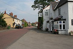
 Main Street, Kilby (2006) | |
Location within Leicestershire | |
| Area | 3.7440326 sq mi (9.697000 km2) |
| Population | 270 (2011) |
| • Density | 72/sq mi (28/km2) |
| OS grid reference | SP6197895424 |
| • London | 100.1 mi (161.1 km) SE |
| Civil parish |
|
| District | |
| Shire county | |
| Region | |
| Country | England |
| Sovereign state | United Kingdom |
| Post town | WIGSTON |
| Postcode district | LE18 |
| Dialling code | 0116 |
| Police | Leicestershire |
| Fire | Leicestershire |
| Ambulance | East Midlands |
| UK Parliament | |
| Website | Kilby Parish Council |
Kilby is a village and civil parish in the Blaby district of Leicestershire, England.[1] Kilby is the easternmost village in the district, and is 6.1 miles (9.8 km) south east of Leicester.[2] Kilby civil parish includes the former parish of Foston and its deserted medieval village. Nearby places are Countesthorpe 2.21 miles (3.56 km), Fleckney 2.12 miles (3.41 km), Arnesby 1.96 miles (3.15 km), Wistow 1.4 miles (2.3 km) and Kilby Bridge 1.18 miles (1.90 km).
In 1870–72, John Marius Wilson's Imperial Gazetteer of England and Wales described Kilby as follows:
"KILBY, a parish, with a village, in Blaby district, Leicestershire; on a branch of the river Soar, and on the Union canal, 2 miles SSE of Wigston r. station, and 6½ SSE of Leicester. Post town, Wigston, under Leicester. Acres, 1, 060. Real property, £2, 200. Pop., 362. Houses, 95. The property is divided among a few. Framework knitting is carried on. The living is a p. curacy in the diocese of Peterborough. Value, £63. Patron, Sir H. Halford, Bart. The church is plain and good, with a very low tower. There is an Independent chapel."[3]
- ^ "Parish and Town Councils". Blaby District Council. Archived from the original on 16 April 2014. Retrieved 16 April 2014.
- ^ "Kilby Church St Mary Magdalene". Leicestershire Churches. 21 December 2012. Archived from the original on 1 March 2014. Retrieved 16 April 2014.
- ^ Marius, John. "Kilby". Wilson's Imperial Gazetteer of England and Wales. Retrieved 31 March 2022.
