Kildorrery
Cill Dairbhre | |
|---|---|
Village | |
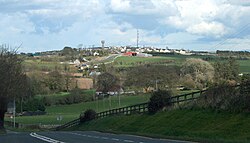
 Kildorrery lies on the N73 road in North Cork | |
| Coordinates: 52°14′46″N 08°25′37″W / 52.24611°N 8.42694°W | |
| Country | Ireland |
| Province | Munster |
| County | County Cork |
| Population | 357 |
| Time zone | UTC+0 (WET) |
| • Summer (DST) | UTC-1 (IST (WEST)) |
Kildorrery (Irish: Cill Dairbhre, meaning 'church of the oak-forest')[2] is a village in north County Cork, Ireland. It lies at the crossroads of the N73 road from Mallow to Mitchelstown and the R512 from Kilmallock to Fermoy. The village is in a townland and civil parish of the same name.[2] Kildorrery is part of the Cork East Dáil constituency.
The village, which sits on a hilltop plateau, overlooks the surrounding area.[3] To the east are the Galtee Mountains and Knockmealdown Mountains, with Slievenamon in the distance. To the north the Ballyhouras – the Limerick road is flanked by two mountains, Castlegale and Carrigeenamronety Hill (Carraigín na mBróinte). To the south, across the Blackwater Valley, are the Nagle mountains.[citation needed]
- ^ "Local population data published following Census 2016". avondhupress.ie. 18 May 2017. Retrieved 17 April 2020.
- ^ a b "Cill Dairbhre / Kildorrery". logainm.ie. Placenames Database of Ireland. Retrieved 10 June 2023.
- ^ Volume Three - North Cork (PDF). Cork County Development Plan 2022 (Report). Cork County Council. 2022. p. 79. Retrieved 10 June 2023.
