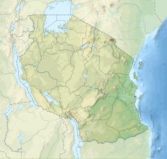
| Kilimanjaro National Park | |
|---|---|
 The entrance to Kilimanjaro national park | |
| Location | Kilimanjaro Region, Tanzania |
| Nearest city | Moshi |
| Coordinates | 3°04′S 37°22′E / 3.067°S 37.367°E |
| Area | 1,688 km2 (652 sq mi) |
| Established | 1973[1] |
| Visitors | c. 52,000 per year[2] |
| Governing body | Tanzania National Parks Authority |
| Website | www |
| Type | Natural |
| Criteria | vii |
| Designated | 1987 (11th session) |
| Reference no. | 403 |
| Region | Africa |
Kilimanjaro National Park is a Tanzanian national park located 300 kilometres (190 mi) south of the equator[1] in the Kilimanjaro Region, Tanzania. The park is located near the region of Moshi.[3] The park includes the whole of Mount Kilimanjaro above the tree line and the surrounding montane forest belt above 1,820 metres (5,970 ft).[1][3] It covers an area of 1,688 square kilometres (652 sq mi), 2°50'–3°10'S 37°10'–37°40'E.[1] The park is administered by the Tanzania National Parks Authority (TANAPA).[4] It was established as a national park in 1973. It was declared a World Heritage Site by UNESCO in 1987 and Natural Wonder of Africa in 2013.[5]
The Park Headquarters is at Marangu, about 44 Km from Moshi town and 86km from Kilimanjaro International Airport
The park generated US$51 million in revenue in 2013,[6]: 285 the second-most of any Tanzanian national park,[7]: 258 and was one of only two Tanzanian national parks to generate a surplus during the 2012–2013 budget year.[8] (The Ngorongoro Conservation Area, which includes the heavily visited Ngorongoro Crater, is not a national park.) TANAPA has reported that the park recorded 58,460 tourists during the 2012–2013 budget year, of whom 54,584 were foreigners.[8] Of the park's 57,456 tourists during the 2011–2012 budget year, 16,425 hiked the mountain, which was well below the capacity of 28,470 as specified in the park's General Management Plan.[9]
- ^ a b c d "Kilimanjaro National Park World Heritage Site, Tanzania National Parks". Archived from the original on 30 September 2018. Retrieved 9 July 2013.
- ^ "Wings of Kili: Paragliding from Arica's highest peak". Daily News (Tanzania). Archived from the original on 29 January 2013. Retrieved 28 January 2013.
- ^ a b Kilimanjaro National Park, World Heritage Center, United Nations Educational, Scientific and Cultural Organization
- ^ Mount Kilimanjaro National Park, Tanzania National Parks Authority Archived 2012-09-23 at the Wayback Machine
- ^ "Kilimanjaro National Park". Climbing Kilimanjaro. Archived from the original on 8 February 2023. Retrieved 15 January 2023.
- ^ Ghazali Musa; James Higham; Anna Thompson-Carr, eds. (5 June 2015). Mountaineering Tourism. Routledge. ISBN 978-1-317-66874-9.
- ^ Ian Christie; Eneida Fernandes; Hannah Messerli; Louise Twining-Ward (2014). Tourism in Africa: Harnessing Tourism for Growth and Improved Livelihoods. World Bank Publications. ISBN 9781464801976.
- ^ a b Park arrivals highlights, Tourism Performance, Corporate Information, Tanzania National Parks, accessed 9 November 2015 Archived 20 December 2015 at the Wayback Machine
- ^ "PRESS STATEMENT: NUMBER OF MOUNT KILIMANJARO CLIMBERS NOT A THREAT", Tanzania National Parks, 5 March 2014, accessed 31 July 2015 Archived 24 September 2015 at the Wayback Machine
