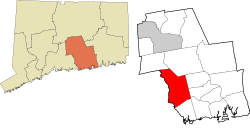
Killingworth, Connecticut | |
|---|---|
| Town of Killingworth | |
 Killingworth Library Association | |
| Coordinates: 41°22′50″N 72°34′35″W / 41.38056°N 72.57639°W | |
| Country | |
| U.S. state | |
| County | Middlesex |
| Region | Lower CT River Valley |
| Named | 1667 |
| Government | |
| • Type | Selectman-town meeting |
| • First Selectman | Eric Couture (D) |
| • Selectman | Joel D'Angelo (D) |
| • Selectman | Eric Nunes (R) |
| Area | |
• Total | 35.8 sq mi (92.7 km2) |
| • Land | 35.3 sq mi (91.5 km2) |
| • Water | 0.5 sq mi (1.2 km2) |
| Elevation | 354 ft (108 m) |
| Population (2020) | |
• Total | 6,174 |
| • Density | 175/sq mi (67.5/km2) |
| Time zone | UTC-5 (Eastern) |
| • Summer (DST) | UTC-4 (Eastern In) |
| ZIP code | 06419 |
| Area code(s) | 860/959 |
| FIPS code | 09-40710 |
| GNIS feature ID | 0213448[1] |
| Website | www |
Killingworth is a town in Middlesex County, Connecticut, United States. The town is part of the Lower Connecticut River Valley Planning Region. The population was 6,174 at the 2020 United States Census.[2]


