| Kilmington | |
|---|---|
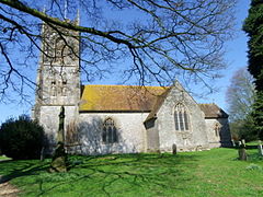
 St Marys Church, Kilmington | |
Location within Wiltshire | |
| Population | 328 (in 2011)[1] |
| OS grid reference | ST772365 |
| Unitary authority | |
| Ceremonial county | |
| Region | |
| Country | England |
| Sovereign state | United Kingdom |
| Post town | Warminster |
| Postcode district | BA12 |
| Dialling code | 01985 |
| Police | Wiltshire |
| Fire | Dorset and Wiltshire |
| Ambulance | South Western |
| UK Parliament | |
| Website | Parish Council |
Kilmington is a village and civil parish in the extreme west of Wiltshire, England, about 8 miles (13 km) southwest of Warminster. The parish includes the hamlets of Kilmington Common and Norton Ferris.
The parish lies on the northern edge of the ancient Selwood Forest. Whitesheet Hill is in the south-east of the parish, and Long Knoll (288m above sea level) is a long ridge on the northern parish boundary. Until 1896 Kilmington was in the historic county of Somerset,[2] as part of the Norton Ferris Hundred.[3]
- ^ "Wiltshire Community History – Census". Wiltshire Council. Retrieved 6 August 2015.
- ^ "Kilmington CP/AP". A Vision of Britain through Time. University of Portsmouth. Retrieved 20 December 2015.
- ^ "Somerset Hundreds". GENUKI. Retrieved 18 October 2011.
