| Kimberley | |
|---|---|
| Town and civil parish | |
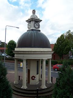
 Kimberley War Memorial | |
 Parish map | |
Location within Nottinghamshire | |
| Area | 1.11 sq mi (2.9 km2) |
| Population | 6,033 (2021) |
| • Density | 5,435/sq mi (2,098/km2) |
| OS grid reference | SK 49995 44702 |
| • London | 110 mi (180 km) SSE |
| District | |
| Shire county | |
| Region | |
| Country | England |
| Sovereign state | United Kingdom |
| Areas of the town | List
|
| Post town | NOTTINGHAM |
| Postcode district | NG16 |
| Dialling code | 0115 |
| Police | Nottinghamshire |
| Fire | Nottinghamshire |
| Ambulance | East Midlands |
| UK Parliament | |
| Website | www |
Kimberley is a market town and civil parish in the Borough of Broxtowe in Nottinghamshire, England, lying 6 miles northwest of Nottingham along the A610. The town grew as a centre for coal mining, brewing and hosiery manufacturing. At the 2011 census the town had a population of 6,053,[1] and this fell to 6,033 at the 2021 census.[2]
- ^ "Broxtowe ward population 2011". Neighbourhood Statistics. Office for National Statistics. Retrieved 11 April 2016.
- ^ UK Census (2021). "2021 Census Area Profile – Kimberley (Broxtowe) parish (E04007860)". Nomis. Office for National Statistics. Retrieved 25 January 2024.
