Kinburn Spit
Кінбурнська коса (Ukrainian) | |
|---|---|
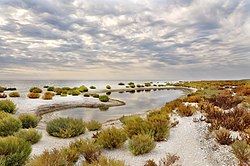
 The Kinburn Spit in autumn | |
 | |
| Coordinates: 46°33′31″N 31°31′40″E / 46.55861°N 31.52778°E | |
| Location | Mykolaiv Raion, Mykolaiv Oblast, Ukraine |
| Part of |  |
| Native name | Кінбурнська коса (Ukrainian) |
| Dimensions | |
| • Length | 10 kilometres (6.2 mi) long |
| • Width | 1 kilometre (0.62 mi) wide |
The Kinburn Spit (Ukrainian: Кінбурнська коса, romanized: Kinbúrnska kosá) is a spit in Mykolaiv Raion, Mykolaiv Oblast, Ukraine.[1] Its only land access is through Kherson Oblast. It occupies the westernmost part of the Kinburn Peninsula, stretching west into the Black Sea between the Dnieper-Bug estuary to the north and the Yahorlyk Bay to the south. It is approximately 10 kilometres (6.2 mi) long, with a width of about 1 kilometre (0.62 mi) at its base, narrowing to about 100 metres (330 ft) in its western half.
During the Russian invasion of Ukraine, the spit was captured by Russian forces on 10 June 2022. Russia fortified the spit and used it as a site to deploy electronic warfare and coordinate missile and artillery attacks on nearby Ukrainian positions. Since Ukraine's 2022 Kherson counteroffensive that ended in November 2022, regained territory north of the spit has allowed Ukrainian forces to more frequently conduct amphibious operations against the spit as reconnaissance for its potential recapture.
- ^ Kinburn Spit TripMustGoOn