This article needs additional citations for verification. (September 2013) |
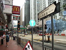
 Fortress Hill section of King's Road | |
| Native name | 英皇道 (Yue Chinese) |
|---|---|
| Former name(s) | Shaukiwan Road |
| Namesake | King George V |
| Length | 4.2 kilometres (2.6 mi) |
| Location | Eastern District, Hong Kong |
| East end | Causeway Road / Hing Fat Road |
| West end | Shau Kei Wan Road / Tai Koo Shing Road |
 | |
| King's Road | |||||||||||
|---|---|---|---|---|---|---|---|---|---|---|---|
| Chinese | 英皇道 | ||||||||||
| |||||||||||


King's Road is a major east–west road along the north of Hong Kong Island, Hong Kong, stretching from Causeway Bay (Tin Hau), where it joins Causeway Road, to Sai Wan Ho, where it joins Shau Kei Wan Road.