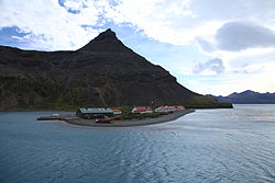
King Edward Point | |
|---|---|
 King Edward Point | |
 Location of King Edward Point and Grytviken in South Georgia | |
| Coordinates: 54°17′00″S 36°29′42″W / 54.283333°S 36.495°W | |
| Country | |
| Territory | South Georgia and the South Sandwich Islands |
| Operator | British Antarctic Survey |
| Established | 1950 |
| Population (2018) | |
| • Summer | 22 |
| • Winter | 12 |
| Time zone | UTC−2 (GST) |
| UN/LOCODE | GS |
| Active times | All year-round |
| Status | Operational |
| Activities | Support sustainable fishing |

King Edward Point (also known as KEP) is a permanent British Antarctic Survey research station on South Georgia island and is the capital of the British Overseas Territory of South Georgia and the South Sandwich Islands.[1] It is situated in Cumberland East Bay on the northeastern coast of the island.[2] The settlement is the second smallest capital in the world by population, after Ngerulmud in Palau.
- ^ "Local laws and customs - South Georgia and South Sandwich Islands (British Overseas Territory) travel advice - GOV.UK". www.gov.uk. Retrieved 28 September 2017.
- ^ "Google Maps". 54°17'00.0"S 36°29'39.0"W. Retrieved 25 July 2018.