| King Fire | |
|---|---|
 A USFS firefighter watches the King Fire torching trees near Pollock Pines on September 14, 2014 | |
| Date(s) |
|
| Location |
|
| Coordinates | 38°46′55″N 120°36′14″W / 38.782°N 120.604°W |
| Statistics[1][2][3] | |
| Burned area | 97,717 acres (39,545 ha; 153 sq mi; 395 km2) |
| Impacts | |
| Deaths | 0 |
| Non-fatal injuries | 12 |
| Evacuated | 2,830 |
| Structures destroyed |
|
| Damage |
|
| Ignition | |
| Cause | Arson |
| Map | |
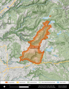
 The footprint of the King Fire, west of Lake Tahoe and north of U.S. Route 50 | |
The 2014 King Fire was a large wildfire in El Dorado County, California, which burned 97,717 acres (39,545 hectares) primarily in the Eldorado National Forest. The wildfire started on September 13, 2014, near Pollock Pines, California, to the east of Sacramento. The ensuing fire suppression effort, which cost more than $100 million and engaged more than 8,000 personnel at its peak, allowed for the full containment of the King Fire by October 9, 2014. Despite the size and ferocity of the fire, it caused no deaths. Eighty structures were destroyed, the majority of them outbuildings. The King Fire was determined to have been caused by an act of arson and a suspect was swiftly apprehended and convicted in 2016.
- ^ Cite error: The named reference
arson-latimeswas invoked but never defined (see the help page). - ^ "Giant King fire burns 10 homes, could be whipped up as weather shifts". Los Angeles Times. September 21, 2014. Retrieved September 22, 2014.
- ^ Cite error: The named reference
inciwebwas invoked but never defined (see the help page).
