An editor has nominated this article for deletion. You are welcome to participate in the deletion discussion, which will decide whether or not to retain it. |
This article has multiple issues. Please help improve it or discuss these issues on the talk page. (Learn how and when to remove these messages)
|
Kingdom of Shukuup | |
|---|---|
| c. 426–c. 9th century | |
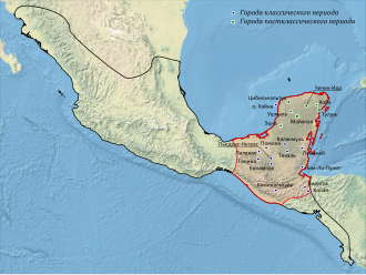
 Map of the largest Mayan cities. The kingdom of Shukuup was located in the extreme southeast of the Mayan lands, which are highlighted in red on the map | |
| Capital | Copan (Khushvitik/Khushvintik) |
| Common languages | Mayan, Lencan, Jicak |
| Religion | Maya Religion |
| Government | Monarchy |
| Ajaw and kaloomte | |
• c. 426 – 437 | K'inich-Yash-K'uk'-Mo [1] |
• c. 437 — ? | K'inich-Popol-Khol[2] |
| Historical era | Maya civilization |
• Established | c. 426 |
• Disestablished | c. 9th century |
| |
The Kingdom of Shukuup [3] was one of the ancient Mayan states, which existed from c. 426 to the 9th century in the territory of modern southeastern Guatemala and northwestern Honduras. Its capital was the settlement Copan, in ancient times called Khushvitik or Khushvintik.[4]
Cite error: There are <ref group=lower-alpha> tags or {{efn}} templates on this page, but the references will not show without a {{reflist|group=lower-alpha}} template or {{notelist}} template (see the help page).
- ^ Stuart, David. ""The Arrival of Strangers": Teotihuacan and Tollan in Classic Maya History". Precolumbian Art Research Institute. Archived from the original on 2014-04-23. Retrieved 2015-03-24.
- ^ Cite error: The named reference
Martin S. 195-196was invoked but never defined (see the help page). - ^ Styuflyaev, M.I. (2010). "Preface (Kingdom of Shukuup)". History of the Mayan Kingdoms (electronic ed.).
- ^ Cite error: The named reference
Awas invoked but never defined (see the help page).
![Hieroglyph-emblem[a]](http://upload.wikimedia.org/wikipedia/commons/thumb/c/ce/Kopan.png/85px-Kopan.png)