| Kinglake Victoria | |||||||||||||||
|---|---|---|---|---|---|---|---|---|---|---|---|---|---|---|---|
 Main street of Kinglake prior to the bushfire of 7 February 2009 | |||||||||||||||
 | |||||||||||||||
| Coordinates | 37°31′58″S 145°20′28″E / 37.53278°S 145.34111°E | ||||||||||||||
| Population | 1,662 (2021 census)[1] | ||||||||||||||
| Postcode(s) | 3763 | ||||||||||||||
| Elevation | 550 m (1,804 ft) | ||||||||||||||
| Location |
| ||||||||||||||
| LGA(s) | |||||||||||||||
| State electorate(s) | Eildon | ||||||||||||||
| Federal division(s) | |||||||||||||||
| |||||||||||||||
| |||||||||||||||

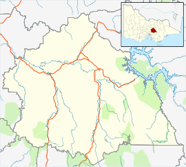
Kinglake is a town in Victoria, Australia, 56 km (35 mi) north-east of Melbourne's Central Business District, located within the Shires of Murrindindi and Nillumbik local government areas. Kinglake is on the traditional lands of the Taungurung and Wurundjeri peoples.
The town was one of the worst affected during the Black Saturday bushfires in 2009.[2]
- ^ Australian Bureau of Statistics (28 June 2022). "Kinglake (Suburbs and Localities)". 2021 Census QuickStats. Retrieved 2 July 2022.
- ^ Rule, Andrew (9 February 2009). "Our darkest day". The Age. Melbourne.
