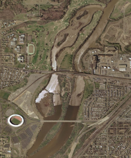
 Kingman and Heritage Islands in the Anacostia River | |
| Geography | |
|---|---|
| Location | Washington, D.C. |
| Coordinates | 38°53′56″N 76°57′52″W / 38.8990000°N 76.9644193°W |
| Total islands | 2 |
| Area | 40 acres (16 ha) (Kingman); 6 acres (2.4 ha) (Heritage)[1] |
| Administration | |
United States | |
| Demographics | |
| Population | 0 (2022) |
Kingman Island (also known as Burnham Barrier) and Heritage Island are islands in Northeast and Southeast Washington, D.C., in the Anacostia River. Both islands are man-made, built from material dredged from the Anacostia River and completed in 1916.[1][2][3][4] Kingman Island is bordered on the east by the Anacostia River, and on the west by 110-acre (45 ha) Kingman Lake.[5] Heritage Island is surrounded by Kingman Lake. Both islands were federally owned property managed by the National Park Service until 1995. They are currently owned by the D.C. government, and managed by Living Classrooms National Capital Region.[6][7] Kingman Island is bisected by Benning Road and the Ethel Kennedy Bridge,[5] with the southern half of the island bisected again by East Capitol Street and the Whitney Young Memorial Bridge. As of 2010, Langston Golf Course occupied the northern half of Kingman Island, while the southern half of Kingman Island and all of Heritage Island remained largely undeveloped. Kingman Island, Kingman Lake and nearby Kingman Park are named after Brigadier General Dan Christie Kingman, the former head of the United States Army Corps of Engineers.[8]
- ^ a b Department of the Interior and Related Agencies Appropriations for 1994..., 1994, p. 79.
- ^ Turner, Justice on Earth: Earthjustice and the People It Has Served, 2002, p. 54.
- ^ Forgey, "The Anacostia, Stream of Consciousness," Washington Post, March 28, 1987.
- ^ Barker, "Clouds Gathering Over Children's Island," Washington Post, August 9, 1991.
- ^ a b United States Congressional Serial Set, Issue 14361, 1998, p. 45.
- ^ "Kingman and Heritage Islands Park". www.kingmanisland.org. Retrieved 2016-02-18.
- ^ "Living Classrooms Foundation". livingclassrooms.org. Retrieved 2016-02-18.
- ^ Forgey, Benjamin. "The Anacostia, Stream of Consciousness." Washington Post. March 28, 1987.
