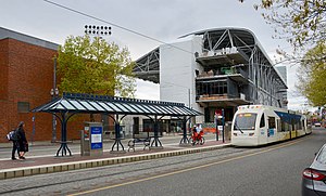
| MAX Light Rail station | ||||||||||||||||
 Viewed from the south in 2019 with the Multnomah Athletic Club and Providence Park in background | ||||||||||||||||
| General information | ||||||||||||||||
| Location | SW 18th Avenue and Salmon Street Portland, Oregon, U.S. | |||||||||||||||
| Coordinates | 45°31′13″N 122°41′28″W / 45.52028°N 122.69111°W | |||||||||||||||
| Owned by | TriMet | |||||||||||||||
| Line(s) | ||||||||||||||||
| Platforms | 1 island platform | |||||||||||||||
| Tracks | 2 | |||||||||||||||
| Construction | ||||||||||||||||
| Accessible | Yes | |||||||||||||||
| Other information | ||||||||||||||||
| Status | Closed | |||||||||||||||
| History | ||||||||||||||||
| Opened | August 31, 1997 | |||||||||||||||
| Closed | March 1, 2020[1] | |||||||||||||||
| Suspended services | ||||||||||||||||
| ||||||||||||||||
| ||||||||||||||||
Kings Hill/Southwest Salmon Street is a former light rail station in Portland, Oregon, United States, which was served by the Blue and Red lines of TriMet's MAX Light Rail. The station was situated within the Goose Hollow neighborhood. Its incorrectly punctuated name refers to the hillside to the west of the station, which has historically been referred to as King's Hill.[2] A section of King's Hill, which contains many historic buildings, qualified for inclusion within the King's Hill Historic District, the easternmost boundary of which is at SW 21st Avenue.[3]
- ^ Altstadt, Roberta (January 24, 2024). "TriMet proposes improvements to make MAX system faster and more reliable". TriMet. Retrieved January 25, 2024.
- ^ Prince, Tracy J. (2011). Portland's Goose Hollow. Charleston, South Carolina: Arcadia Publishing. ISBN 978-0-7385-7472-1.
- ^ "King's Hill Historic District Guidelines" (PDF). Planning Bureau, City of Portland. 2001. pp. 133–138. Retrieved June 13, 2011.
