Kinsarvik Municipality
Kinsarvik herad | |
|---|---|
| Kinservik herred (historic name) | |
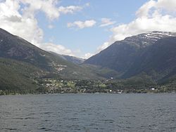
 View of Kinsarvik | |
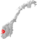
 Hordaland within Norway | |
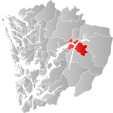
 Kinsarvik within Hordaland | |
| Coordinates: 60°22′28″N 06°43′12″E / 60.37444°N 6.72000°E | |
| Country | Norway |
| County | Hordaland |
| District | Hardanger |
| Established | 1 Jan 1838 |
| • Created as | Formannskapsdistrikt |
| Disestablished | 1 Jan 1869 |
| • Succeeded by | Ullensvang Municipality |
| Re-established | 1 Jan 1913 |
| • Preceded by | Ullensvang Municipality |
| Disestablished | 1 Jan 1964 |
| • Succeeded by | Ullensvang Municipality |
| Administrative centre | Kinsarvik |
| Area (upon dissolution) | |
| • Total | 382 km2 (147 sq mi) |
| Population (1963) | |
| • Total | 1,585 |
| • Density | 4.1/km2 (11/sq mi) |
| Time zone | UTC+01:00 (CET) |
| • Summer (DST) | UTC+02:00 (CEST) |
| ISO 3166 code | NO-1231[1] |
Kinsarvik is a former municipality in the old Hordaland county, Norway. The administrative centre of the municipality was the village of Kinsarvik where Kinsarvik Church is located. The municipality of Kinsarvik existed two different times: from 1838 until 1869 and then again from 1913 until 1964. The municipality centered on the inner part of the Hardangerfjorden, and (originally) surrounded all of the Sørfjorden. The original Kinsarvik encompassed all of the present day municipalities of Ullensvang (except for Røldal) and a small part of Voss. Upon its final dissolution in 1964, it covered an area of 382 square kilometres (147 sq mi).[2]
- ^ Bolstad, Erik; Thorsnæs, Geir, eds. (26 January 2023). "Kommunenummer". Store norske leksikon (in Norwegian). Kunnskapsforlaget.
- ^ Store norske leksikon. "Kinsarvik. – kommune" (in Norwegian). Retrieved 2 June 2014.