You can help expand this article with text translated from the corresponding article in Japanese. (December 2016) Click [show] for important translation instructions.
|
Kitakyushu
北九州市 | |
|---|---|
| City of Kitakyushu[1] | |
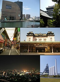
 Clockwise from top left: the Riverwalk shopping center; Kokura Castle; Mojiko Station; the former Higashida blast furnace; a night view of Kokura from Mount Adachi; and the Tanga Market in Kokura | |
 Location of Kitakyushu in Fukuoka Prefecture | |
 | |
| Coordinates: 33°53′N 130°53′E / 33.883°N 130.883°E | |
| Country | Japan |
| Region | Kyushu |
| Prefecture | Fukuoka Prefecture |
| Government | |
| • Mayor | Kazuhisa Takeuchi |
| Area | |
• Total | 491.95 km2 (189.94 sq mi) |
| Population (June 1, 2019) | |
• Total | 940,978 |
| • Density | 1,900/km2 (5,000/sq mi) |
| Time zone | UTC+09:00 (JST) |
| City hall address | 1-1 Jōnai, Kokura Kita-ku, Kitakyushu-shi, Fukuoka-ken 803-8501 |
| Climate | Cfa |
| Website | www |
| Symbols | |
| Flower | Tsutsuji (Azalea) Himawari (Sunflower) |
| Tree | Ichiigashi (Japanese beech) |
Kitakyushu (Japanese: 北九州市, Hepburn: Kitakyūshū-shi) is a city located in Fukuoka Prefecture, Japan. As of June 1, 2019, Kitakyushu has an estimated population of 940,978, making it the second-largest city in both Fukuoka Prefecture and the island of Kyushu after the city of Fukuoka. It is one of Japan's 20 designated cities, one of three on Kyushu, and is divided into seven wards.
Kitakyushu was formed in 1963 from a merger of municipalities centered on the historic city of Kokura, and its name literally means "North Kyushu City" in Japanese. It is located at the northernmost point of Kyushu on the Kanmon Straits, separating the island from Honshu, across from the city of Shimonoseki. Kitakyushu and Shimonoseki are connected by numerous transport links including the Kanmon Bridge and the Kanmon Tunnels (Roadway, Railway, and Shin-Kanmon). Kitakyushu's Urban Employment Area forms part of the Fukuoka-Kitakyushu Greater Metropolitan Region, which, with a population of 5,738,977 (2005-2006), is the largest metropolitan area in Japan west of the Keihanshin region.
- ^ Kitakyushu's official English name Archived 2012-05-11 at the Wayback Machine


