Kittanning | |
|---|---|
 The Kittanning Citizens Bridge, Armstrong County Courthouse, and downtown of Kittanning | |
| Etymology: Lenape kithanink, 'on the main river' | |
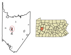
 Location of Kittanning in Armstrong County, Pennsylvania. | |
| Coordinates: 40°49′12″N 79°31′17″W / 40.82000°N 79.52139°W | |
| Country | United States |
| State | Pennsylvania |
| County | Armstrong County |
| Settled | 1727 (Native American village) |
| Settled | 1803 (Borough) |
| Area | |
• Total | 1.25 sq mi (3.24 km2) |
| • Land | 1.00 sq mi (2.58 km2) |
| • Water | 0.25 sq mi (0.66 km2) |
| Population | |
• Total | 3,921 |
| • Density | 3,936.75/sq mi (1,519.46/km2) |
| Time zone | UTC−5 (EST) |
| • Summer (DST) | UTC−4 (EDT) |
| ZIP Code | 16201 |
| Area code | 724 |
| FIPS code | 42-40040 |
| School district | Armstrong |
| Website | Borough website |
Kittanning (/kɪˈtænɪŋ/ ki-TAN-ing) is a borough in and the county seat of Armstrong County, Pennsylvania, United States.[3] It is situated 36 miles (58 km) northeast of Pittsburgh, along the east bank of the Allegheny River. The population was 3,921 at the 2020 census.
The name is derived from Kithanink,[4] which means 'on the main river' in Lenape or the Delaware language, from kit- 'big' + hane 'mountain river' + -ink (suffix used in place names). "The main river" is a Lenape term for the Allegheny and Ohio combined, which they considered as all one river.[5] The borough and its bridge have been used as a setting for several recent films.
- ^ "ArcGIS REST Services Directory". United States Census Bureau. Retrieved October 12, 2022.
- ^ Cite error: The named reference
USCensusDecennial2020CenPopScriptOnlywas invoked but never defined (see the help page). - ^ "Find a County". National Association of Counties. Archived from the original on May 31, 2011. Retrieved June 7, 2011.
- ^ "kithanink". Lenape Talking Dictionary. Archived from the original on March 15, 2012. Retrieved June 11, 2012.
- ^ Smith, Robert Walker (1883). History of Armstrong County, Pennsylvania. Chicago: Waterman, Watkins, & Co. Archived from the original on June 1, 2014. Retrieved June 12, 2012.