| Kittatinny Mountain | |
|---|---|
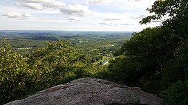
 The Kittatinny Valley seen from Sunrise Mountain lookout | |
| Highest point | |
| Elevation | 1,803 feet (at High Point) |
| Coordinates | 41°08′10″N 74°47′49″W / 41.136°N 74.797°W |
| Geography | |
 | |
| Location | New Jersey, United States |
| Parent range | Ridge-and-valley Appalachians |
Kittatinny Mountain (Lenape: Kitahtëne[1]) is a long ridge traversing primarily across Sussex County in northwestern New Jersey, running in a northeast-southwest axis, a continuation across the Delaware Water Gap of Pennsylvania's Blue Mountain (also known as Kittatinny Ridge). It is the first major ridge in the far northeastern extension of the Ridge and Valley province of the Appalachian Mountains, and reaches its highest elevation (the state's highest), 1,803 feet, at High Point in Montague Township. Kittatinny Mountain forms the eastern side of Wallpack Valley; the western side comprises the Wallpack Ridge (highest elevation: 928 feet (283 m) above sea level.
- ^ "Lenape Talking Dictionary". Archived from the original on December 11, 2013. Retrieved May 27, 2012.