| Klawatti Peak | |
|---|---|
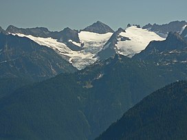
 Klawatti Peak (center) lies between Austera Peak (left) and Tepeh Towers (right). Three-lobed McAllister Glacier covers its northwest face. | |
| Highest point | |
| Elevation | 8,485 ft (2,586 m)[1] |
| Prominence | 685 ft (209 m)[1] |
| Coordinates | 48°33′16″N 121°06′16″W / 48.55444°N 121.10444°W[2] |
| Geography | |
| Country | United States |
| State | Washington |
| County | Skagit |
| Protected area | North Cascades National Park Stephen Mather Wilderness |
| Parent range | Cascade Range |
| Topo map | USGS Forbidden Peak |
| Geology | |
| Rock type | Eldorado Orthogneiss |
| Climbing | |
| First ascent | 1940 by Lloyd Anderson, Karl Boyer, Tom Gorton[3] |
Klawatti Peak (8,485 feet (2,586 m)) is located in North Cascades National Park in the U.S. state of Washington.[4] Klawatti Peak is a nunatak, a peak surrounded by glaciers. These are Klawatti Glacier to the east, McAllister Glacier to the northwest and Inspiration Glacier to the south.
- ^ a b "Klawatti Peak, Washington". Peakbagger.com. Retrieved 2013-02-10.
- ^ "Klawatti Peak". Geographic Names Information System. United States Geological Survey, United States Department of the Interior. Retrieved 2013-02-10.
- ^ Cite error: The named reference
Beckey, Fred W 2008was invoked but never defined (see the help page). - ^ Forbidden Peak, WA (Map). TopoQwest (United States Geological Survey Maps). Retrieved 2013-02-10.

