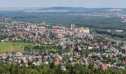
Klosterneuburg | |
|---|---|
 | |
| Coordinates: 48°18′15″N 16°19′00″E / 48.30417°N 16.31667°E | |
| Country | Austria |
| State | Lower Austria |
| District | Tulln |
| Government | |
| • Mayor | Stefan Schmuckenschlager (ÖVP) |
| Area | |
• Total | 76.2 km2 (29.4 sq mi) |
| Elevation | 192 m (630 ft) |
| Population (2018-01-01)[2] | |
• Total | 27,058 |
| • Density | 360/km2 (920/sq mi) |
| Time zone | UTC+1 (CET) |
| • Summer (DST) | UTC+2 (CEST) |
| Postal code | 340x |
| Area code | 02243 |
| Vehicle registration | KG |
| Website | www.klosterneuburg.at |
Klosterneuburg (German pronunciation: [kloːstɐˈnɔɪ̯bʊʁk] ), frequently abbreviated to Kloburg[3] by locals, is a town in the Tulln District of the Austrian state of Lower Austria. It has a population of about 27,500. The Stift Klosterneuburg (Klosterneuburg Monastery), which was established in 1114 and soon after given to the Augustinians, is of particular historical importance.
- ^ "Dauersiedlungsraum der Gemeinden Politischen Bezirke und Bundesländer - Gebietsstand 1.1.2018". Statistics Austria. Retrieved 10 March 2019.
- ^ "Einwohnerzahl 1.1.2018 nach Gemeinden mit Status, Gebietsstand 1.1.2018". Statistics Austria. Retrieved 9 March 2019.
- ^ "KLOBURG Strecken!!". Retrieved 20 May 2023.


