Native name: เกาะพีพีดอน | |
|---|---|
 Beach, Phi Phi Don | |
 | |
| Geography | |
| Location | Strait of Malacca |
| Coordinates | 7°45′10″N 98°46′43″E / 7.7529°N 98.7786°E |
| Archipelago | Phi Phi Islands |
| Area | 9.73 km2 (3.76 sq mi) |
| Length | 3.5 km (2.17 mi) |
| Width | 8 km (5 mi) |
| Administration | |
| Province | |
| District | Mueang Krabi |
| Tambon | Ao Nang |
| Largest Village | Ban Ko Phi Phi |
| Demographics | |
| Languages | Thai, Southern Thai |
| Additional information | |
| Time zone | |
| Postal code | 81xxx |


Ko Phi Phi Don (Thai: เกาะพีพีดอน, RTGS: Ko Phiphi Don, pronounced [kɔ̀ʔ pʰīː.pʰīː dɔ̄ːn]) is the largest of the islands in the Phi Phi archipelago, in Thailand. Phi Phi Don is 9.73 km2 (3.76 mi2): 8 kilometres (5.0 miles) in length and 3.5 kilometres (2.2 miles) wide. Part of the islands are administratively part of Ao Nang in Krabi Province. It is the only island in the group with permanent inhabitants, although most are temporary workers servicing the tourist trade.
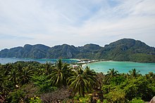
Like the other islands in the archipelago, Phi Phi Don is a non-volcanic island largely made of limestone. It is almost separated into two islands, but a strand of flat land connects them. On this strand lies the largest settlement on the island, as well as most of the resorts.