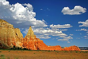
| Kodachrome Basin State Park | |
|---|---|
IUCN category V (protected landscape/seascape) | |
 | |
| Location | Kane, Utah, United States |
| Coordinates | 37°30′2″N 112°0′2″W / 37.50056°N 112.00056°W |
| Area | 2,240 acres (9.1 km2)[1] |
| Elevation | 5,800 ft (1,800 m)[2] |
| Established | 1962 |
| Named for | Kodachrome film |
| Visitors | 160,956 (in 2022)[3] |
| Operator | Utah State Parks |
Kodachrome Basin is a state park of Utah, United States. It is situated 5,800 feet (1,767.8 m) above sea level, 12 miles (19 km) south of Utah Route 12, and 20 miles (32 km) southeast of Bryce Canyon National Park. It is accessible from the north from Cannonville by a paved road and from the south by Road 400, a dirt road from the Page, Arizona area to Cannonville, passable for most vehicles in dry conditions. A longer but paved route to Tropic from the south is also available via US-89 and SR-12.
- ^ Utah.com. "Kodachrome Basin State Park". Utah.com LC. Retrieved February 9, 2011.
- ^ "Kodachrome Basin State Park: About the Park". Utah State Parks. Archived from the original on July 22, 2014. Retrieved June 28, 2014.
- ^ "Park Visitation Data". Utah State Parks. July 6, 2023.

