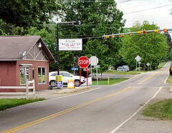
Kodak, Tennessee | |
|---|---|
| Kodak | |
 Intersection of Douglas Dam Road (TN-139) and Kodak Road in Kodak | |
Location within the State of Tennessee | |
| Coordinates: 35°58′28″N 83°37′37″W / 35.97444°N 83.62694°W | |
| Country | United States |
| State | Tennessee |
| County | Sevier |
| City | Sevierville |
| Elevation | 896 ft (273 m) |
| Time zone | UTC-5 (Eastern Time Zone) |
| • Summer (DST) | UTC-4 (EDT) |
| ZIP code | 37764 |
| Area code | 865 |
| GNIS feature ID | 1290403[1] |
Kodak is an unincorporated community and a neighborhood of Sevierville[2] in Sevier County, Tennessee, United States. The small city is located along State Route 139 and State Route 66, and just south of I-40 and Knoxville, Tennessee. The elevation of the city of Kodak is about 896 feet (273 meters) above sea level.
The city of Kodak is included in Sevierville's urban growth boundary for future annexation.[3]
- ^ "Kodak, Tennessee". Geographic Names Information System. United States Geological Survey, United States Department of the Interior.
- ^ "Neighborhood". Kodak Crossing. Retrieved February 14, 2021.
- ^ "Urban Growth Plan - Sevier County" (PDF). Tennessee Advisory Commission on Intergovernmental Relations. State of Tennessee. February 2001. Retrieved February 14, 2021.

