Native name: Qallunaaq (White Man's Island) | |
|---|---|
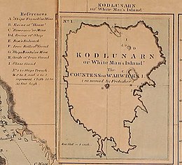
 1865 map of Kodlunarn Island by Charles Francis Hall, noting major archaeological features | |
| Geography | |
| Location | Northern Canada |
| Coordinates | 62°49′N 65°25′W / 62.817°N 65.417°W[1] |
| Archipelago | Arctic Archipelago |
| Area | 7 ha (17 acres) |
| Administration | |
Canada | |
| Territory | Nunavut |
| Additional information | |
| Designated 1964 | |
Kodlunarn Island, known as Qallunaaq[note 1] (White Man's Island) in Inuktitut[3]: 8 and originally named Countess of Warwick Island, is a small island located in Frobisher Bay in the Canadian territory of Nunavut.[4] During the 1570s, explorer Martin Frobisher led expeditions to the island to mine what he believed was gold ore. The ore turned out to be worthless, and the island was ignored by explorers until Charles Francis Hall, inspired by oral history accounts from the Inuit of Frobisher Bay, visited the site in 1861 to investigate the remains of Frobisher's expeditions. Notable features of the island include two large mining trenches and the remains of a stone house built by Frobisher in 1578. Kodlunarn Island was designated a National Historic Site of Canada in 1964.
- ^ "Kodlunarn Island". Geographical Names Data Base. Natural Resources Canada.
- ^ Cite error: The named reference
NHSCwas invoked but never defined (see the help page). - ^ Cite error: The named reference
Alsford1993was invoked but never defined (see the help page). - ^ Cite error: The named reference
geonameswas invoked but never defined (see the help page).
Cite error: There are <ref group=note> tags on this page, but the references will not show without a {{reflist|group=note}} template (see the help page).

