Koerich
Käerch (Luxembourgish) | |
|---|---|
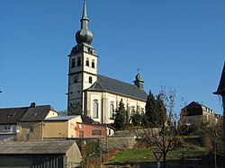
 Koerich church | |
 Map of Luxembourg with Koerich highlighted in orange, and the canton in dark red | |
| Coordinates: 49°40′00″N 5°57′00″E / 49.6667°N 5.95°E | |
| Country | |
| Canton | Capellen |
| Government | |
| • Mayor | Daniel Wirth |
| Area | |
• Total | 18.88 km2 (7.29 sq mi) |
| • Rank | 62nd of 100 |
| Highest elevation | 368 m (1,207 ft) |
| • Rank | 74th of 100 |
| Lowest elevation | 262 m (860 ft) |
| • Rank | 65th of 100 |
| Population (2023) | |
• Total | 2,706 |
| • Rank | 58th of 100 |
| • Density | 140/km2 (370/sq mi) |
| • Rank | 54th of 100 |
| Time zone | UTC+1 (CET) |
| • Summer (DST) | UTC+2 (CEST) |
| LAU 2 | LU0000106 |
| Website | koerich.lu |
Koerich (Luxembourgish: Käerch) is a commune and village in western Luxembourg. It is part of the canton of Capellen.
As of 2023[update], the commune of Koerich has a population of 2,706. The other small communities in the commune are Goeblange, Goetzingen and Windhof. With its onion-towered church standing above the ruins of the medieval castle, Koerich has a particularly attractive rural setting although it is only 15 km west of Luxembourg City.
