| Koh-i-Sultan | |
|---|---|
| Koh-e-Sultan, Kuh-i-Sultan, Kuh-e-Sultan | |
| Highest point | |
| Elevation | 2,334 m (7,657 ft) |
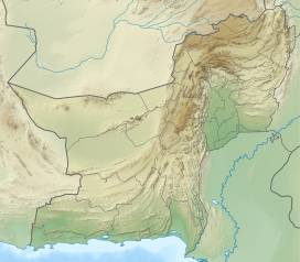
| Coordinates | 29°7′20″N 62°49′1″E / 29.12222°N 62.81694°E |
| Naming | |
| English translation | Mountain of the King |
| Geography | |
| Location | Balochistan, Pakistan |
| Geology | |
| Rock age | Miocene-Late Pleistocene |
| Mountain type | Stratovolcano |
| Volcanic arc | Sultan/Makran/Baluchistan volcanic arc |
| Last eruption | 90,000 ± 10,000 years ago |

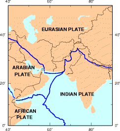
Koh-i-Sultan is a volcano in Balochistan, Pakistan. It is part of the tectonic belt formed by the collision of the Eurasian Plate and Indian Plate: specifically, a segment influenced by the subduction of the Arabian plate beneath the Asian plate and forming a volcanic arc which includes the Bazman and Taftan volcanoes in Iran. The volcano consists of three main cones, with heavily eroded craters running west-northwest and surrounded by a number of subsidiary volcanic centres. Its summit is 2,334 metres (7,657 ft) high, and the crater associated with the Miri cone has a smaller crater inside.
The volcano is formed by andesite and dacite rocks, with fragmentary rocks prevailing over lava flows. The rocks have typical arc-volcano chemistry and composition, with a progression from andesite to dacite in the eruption products with younger age. Potassium-argon dating has indicated an age range from 5,900,000 to 90,000 years. Subsequent erosion has generated a large debris apron around the base of the volcano and carved rock formations which impressed early explorers; one well-known rock formation is Neza e Sultan.
Geothermal activity and the emission of volcanic gases are ongoing, and the volcano has been prospected for the possibility of obtaining geothermal energy. The geothermal activity has resulted in widespread rock alteration and the formation of sulfur deposits, which were mentioned in a 1909 report and later mined. Koh-i-Sultan also has deposits of other minerals.

