| Kokshetau National Park | |
|---|---|
| Көкшетау ұлттық паркі (Kazakh) | |
 Kokshetau National Park | |
| Location | Aqmola Region, Karaganda Region |
| Nearest city | Kokshetau |
| Coordinates | 53°15′N 68°26′E / 53.250°N 68.433°E |
| Area | 182,076 hectares (449,920 acres; 1,821 km2; 703 sq mi) |
| Established | 1996 |
| Governing body | Committee of Forestry and Fauna of the Ministry of Agriculture, Kazakhstan |
| Website | http://www.kokshe.gnpp.kz/content/novosti |
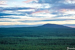
Kokshetau National Park (Kazakh: Kökşetau ūlttyq parkı) features the unique landscape, archaeological sites, and recreational opportunities of the Kazakh Uplands of northern Kazakhstan. Located in the transition zone between the Siberian taiga (to the north) and the southern steppes, the terrain is an "island" of forests, lakes, and mountains surrounded by steppe.[1] Kokshetau is located in Zerendi District, Aqmola Region and Aiyrtau District, North Kazakhstan Region. The park boundary is 45 kilometres (28 mi) west of the city of Kokshetau itself, and 275 kilometres (171 mi) northwest of the capital city of Nur-Sultan.
- ^ "Kokshetau". Official website of the park. Kokshetau National Park. Archived from the original on 18 September 2016. Retrieved 8 June 2017.
