| Kolyma Mountains | |
|---|---|
| Колымское нагорье | |
 Mountains in the Tenkinsky District | |
| Highest point | |
| Peak | Gora Nevskaya |
| Elevation | 1,828 m (5,997 ft) |
| Dimensions | |
| Length | 1,300 km (810 mi) |
| Geography | |
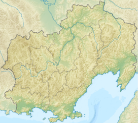
Location in the Far Eastern Federal District, Russia | |
| Country | Russia |
| Oblast/Okrug/Krai | Magadan, Chukotka and Kamchatka |
| Range coordinates | 64°N 159°E / 64°N 159°E |
| Parent range | East Siberian System |
| Geology | |
| Rock age(s) | Jurassic, Triassic, Permian and Proterozoic |
| Rock type(s) | Granite, Gneiss, Schist, Siltstone and Sandstone |
The Kolyma Mountains or Kolyma Upland (Russian: Колымское нагорье, romanized: Kolymskoye Nagorye), is a system of mountain ranges in northeastern Siberia, lying mostly within the Magadan Oblast, along the shores of the Sea of Okhotsk in the Kolyma region.[1] It constitutes the watershed between the basins of Kolyma River and of the Sea of Okhotsk / Pacific Ocean.[2]
The range's highest point is Mount Nevskaya (гора Невская) in the Omsukchan Range at 1,828 meters (5,997 ft).[3]
- ^ "Kolyma Upland". Encyclopædia Britannica. July 20, 1998.
- ^ Cite error: The named reference
ЭСБЕwas invoked but never defined (see the help page). - ^ Sedov RV, Kolyma highland / Hvorov A. Yu . - Khabarovsk, 2003. - p. 418. - ISBN 5-901725-05-0 .

