This article needs additional citations for verification. (July 2023) |
You can help expand this article with text translated from the corresponding article in Finnish. (December 2009) Click [show] for important translation instructions.
|
Konala
Kånala | |
|---|---|
 The regional road 120 (Vihdintie) in Konala | |
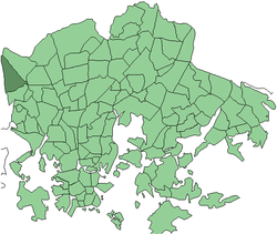
 Position of Konala within Helsinki | |
| Country | |
| Region | Uusimaa |
| Sub-region | Greater Helsinki |
| Municipality | Helsinki |
| District | Western |
Area | 2.32 km2 (0.90 sq mi) |
| Population | 4,450 |
| • Density | 1,918/km2 (4,970/sq mi) |
| Postal codes | 00390 |
| Subdivision number | 32 |
| Neighbouring subdivisions | Pitäjänmäki Malminkartano Kannelmäki |
Konala (Finnish), Kånala (Swedish) is a subdistrict of Helsinki, Finland. Konala is situated in north-western Helsinki, north of the road Ring I and Pitäjänmäki, west of Malminkartano and Kannelmäki. Its southern boundary is the Ring I, while the eastern boundary is a green belt which separates the industrial area along the road Vihdintie from Malminkartano. In the west, Konala borders Espoo.
The houses are mainly small apartment houses and townhouses. The area also contains industrial and commercial enterprises. Vihdintie has several automotive companies. The Ristikko Shopping Centre, which opened in 2015, is also located in Konala.[1]
The road Konalantie splits Konala into two different parts. On the eastern side of the Konalantie, there are regional blocks of industry, business and apartment blocks. On the western side of the road, there are terraced houses, such as the houses by the road Äestäjäntie. The newer Lehtovuori suburb, between the road Vihdintie and the Uusmäki suburb in Espoo, is mainly composed of wooden houses.
Konalan ala-aste, a primary school, operates at two separate locations. The so-called "big school" is located by the Riihipellonkuja and was founded in 1981. The schoolhouse is a low white building, and it provides education for grades 1-6 as well as special education. Near the border with Espoo, there is the Hilatien Koulu, which was founded in 1990 and provided education for the grades 1–2. The "little school" was closed in 2011/2012 due to poor indoor air quality.
- ^ Kauppakeskus Ristikossa jouluvalmistelut aloitettiin jo kesällä - Newsbox.fi (in Finnish)