Kondapalli | |
|---|---|
 Kondapalli aerial view | |
 Interactive map | |
| Coordinates: 16°37′06″N 80°32′28″E / 16.61833°N 80.54111°E | |
| Country | |
| State | Andhra Pradesh |
| Region | Coastal Andhra |
| District | NTR |
| Mandal | Ibrahimpatnam |
| City | Vijayawada |
| Government | |
| • Type | Mayor-council |
| • Body | Kondapalli Municipality |
| Area | |
• Total | 30.00 km2 (11.58 sq mi) |
| Population (2011) | |
• Total | 33,373 |
| • Density | 1,100/km2 (2,900/sq mi) |
| Languages | |
| • Official | Telugu |
| Time zone | UTC+5:30 (IST) |
| PIN | 521228 |
| Telephone code | +91-866 |
| Vehicle registration | AP-16 |


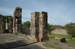
Kondapalli (also known as Mustafanagar) is an industrial and residential hub located in western part of Vijayawada in the Indian state of Andhra Pradesh. Dr Narla Tata Rao Thermal Power Station, one of the major Thermal Power stations of the state is located in between Ibrahimpatnam and Kondapalli. It is home for many industries like Andhra Pradesh Heavy Machinery & Engineering Limited (APHMEL), BPCL, HPCL, IOC, Reliance Industries, Lanco Infratech are located here. Kondapalli Toys are very famous in the state. Kondapalli Fort, also known as Kondapalli Kota, is located towards west of Kondapalli. The closest locality to Kondapalli is Ibrahimpatnam.
