| Kopet Dag woodlands and forest steppe | |
|---|---|
 Hills outside of the city of Ashgabat | |
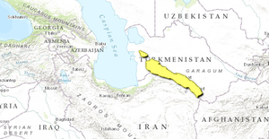
 Ecoregion territory (in yellow) | |
| Ecology | |
| Realm | Palearctic |
| Biome | Montane grasslands and shrublands |
| Geography | |
| Area | 58,274 km2 (22,500 sq mi) |
| Country | Turkmenistan, Iran |
| Coordinates | 38°15′N 57°45′E / 38.25°N 57.75°E |
The Kopet Dag woodlands and forest steppe ecoregion (WWF ID: PA1008) coincides with the Kopet Dag mountains, straddling the southern border of Turkmenistan and the northeastern border of Iran. The region is one of high biodiversity, as it includes a full range of altitude zones (from semi-desert low hills at 300 metres (980 ft) to rocky heights over 2,800 metres (9,200 ft)), and variety of habitats included juniper-wooded slopes, montane grasslands, and tugay (riverine thickets).[1][2][3]
- ^ "Kopet Dag woodlands and forest steppe". World Wildlife Federation (WWF). Retrieved June 22, 2020.
- ^ "Map of Ecoregions 2017". Resolve, using WWF data. Retrieved September 14, 2019.
- ^ "Kopet Dag Biosphere Reserve, Islamic Republic of Iran". UNESCO. 13 July 2018. Retrieved June 28, 2020.