This article needs additional citations for verification. (December 2009) |
Koppies
Kopjes | |
|---|---|
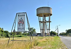
 Koppies entrance | |
| Coordinates: 27°14′S 27°35′E / 27.233°S 27.583°E | |
| Country | South Africa |
| Province | Free State |
| District | Fezile Dabi |
| Municipality | Ngwathe |
| Area | |
| • Total | 7.5 km2 (2.9 sq mi) |
| Population (2011)[1] | |
| • Total | 13,803 |
| • Density | 1,800/km2 (4,800/sq mi) |
| Racial makeup (2011) | |
| • Black African | 94.9% |
| • Coloured | 0.4% |
| • Indian/Asian | 0.3% |
| • White | 3.9% |
| • Other | 0.4% |
| First languages (2011) | |
| • Sotho | 79.5% |
| • Xhosa | 6.1% |
| • Afrikaans | 4.9% |
| • Zulu | 2.7% |
| • Other | 6.7% |
| Time zone | UTC+2 (SAST) |
| Postal code (street) | 9540 |
| PO box | 9540 |
| Area code | 056 |
| Website | www.koppies.info |
Koppies is a small town (railway station) situated near the Renoster River in the Free State province of South Africa.

