| Koroit Victoria | |
|---|---|
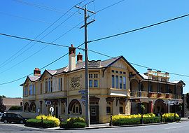
 Koroit Hotel. The signpost at the right of the picture gives distances to towns in Ireland. | |
| Coordinates | 38°17′0″S 142°22′0″E / 38.28333°S 142.36667°E |
| Population | 2,055 (2016 census)[1] |
| Established | 1857 |
| Postcode(s) | 3282 |
| Location |
|
| LGA(s) | Shire of Moyne |
| State electorate(s) | South-West Coast |
| Federal division(s) | Wannon |
Koroit /kəˈrɔɪt/[2] is a small rural town in western Victoria, Australia a few kilometres north of the Princes Highway, 18 kilometres (11 mi) north-west of Warrnambool and 272 kilometres (169 mi) west of Melbourne. It is in the Shire of Moyne local government area located amidst rolling green pastures on the north rim of Tower Hill. At the 2016 census, Koroit had a population of 2,055.[1] The town borrows its name from the Koroitch Gundidj people who occupied the area prior to European colonisation.
- ^ a b Australian Bureau of Statistics (27 June 2017). "Koroit (SSC)". 2016 Census QuickStats. Retrieved 9 July 2017.
- ^ Butler, S., ed. (2009). "Koroit". Macquarie Dictionary (5th ed.). Sydney: Macquarie Dictionary Publishers Pty Ltd. ISBN 978-1-876429-66-9.
