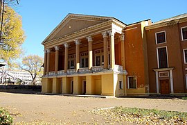
Kostiantynivka
Костянтинівка | |
|---|---|
| |
| Coordinates: 48°32′N 37°43′E / 48.533°N 37.717°E | |
| Country | |
| Oblast | Donetsk Oblast |
| Raion | Kramatorsk Raion |
| Hromada | Kostiantynivka urban hromada |
| Founded | 1870 |
| Area | 66 km2 (25 sq mi) |
| Population (2022) | 67,350 |
| • Density | 1,000/km2 (3,000/sq mi) |
Kostiantynivka (Ukrainian: Костянтинівка, IPA: [kosʲtʲɐnˈtɪn⁽ʲ⁾iu̯kɐ] ; Russian: Константиновка, romanized: Konstantinovka) is an industrial city in Donetsk Oblast, eastern Ukraine. It is situated on the Kryvyi Torets river. During the Soviet era, the city developed into a major centre for the production of iron, zinc, steel, and glass. Administratively, it is incorporated as a city of oblast significance. It was the administrative center of the Kostiantynivka Raion until 2020, although it did not belong to it. After the raion was abolished, Kostiantynivka was incorporated into the Kramatorsk Raion. Its population is approximately 67,350 (2022 estimate).[1]
| Year | Pop. | ±% |
|---|---|---|
| 1926 | 25,404 | — |
| 1939 | 95,807 | +277.1% |
| 1959 | 88,723 | −7.4% |
| 1970 | 105,446 | +18.8% |
| 1979 | 112,020 | +6.2% |
| 1989 | 107,562 | −4.0% |
| 2001 | 95,111 | −11.6% |
| 2011 | 79,211 | −16.7% |
| 2022 | 67,350 | −15.0% |
| Source: [2] | ||
- ^ Чисельність наявного населення України на 1 січня 2022 [Number of Present Population of Ukraine, as of January 1, 2022] (PDF) (in Ukrainian and English). Kyiv: State Statistics Service of Ukraine. Archived (PDF) from the original on 4 July 2022.
- ^ "Cities & Towns of Ukraine".


