| Kowloon Peak | |
|---|---|
| 飛鵝山 | |
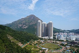
 View of Kowloon Peak | |
| Highest point | |
| Elevation | 602 m (1,975 ft) Hong Kong Principal Datum |
| Coordinates | 22°20′27.16″N 114°13′23.64″E / 22.3408778°N 114.2232333°E |
| Geography | |
| Location | |
| Kowloon Peak | |||||||||||||||||
|---|---|---|---|---|---|---|---|---|---|---|---|---|---|---|---|---|---|
| Traditional Chinese | 飛鵝山 | ||||||||||||||||
| Simplified Chinese | 飞鹅山 | ||||||||||||||||
| Cantonese Yale | Fēi ngòh shāan | ||||||||||||||||
| Literal meaning | Soaring Goose Mountain | ||||||||||||||||
| |||||||||||||||||
Kowloon Peak,[1] also known as Fei Ngo Shan (literally: "Soaring Goose Mountain", Chinese: 飛鵝山), is a 1,975-foot-tall (602 m) mountain in the northeast corner of New Kowloon, Hong Kong, situated in Ma On Shan Country Park.[2] With the summit located just to the east of the border between Wong Tai Sin and Sai Kung districts,[3] it is the tallest mountain in Kowloon, and is crossed by both the Wilson Trail and the MacLehose Trail.
On the lower slopes of Tung Yeung Shan about 1.1 miles (1.8 kilometres) to the north is the Gilwell Campsite, belonging to The Scout Association.
- ^ "GeoInfo Map.Map of Hong Kong provided by HKSARG". www.map.gov.hk. Retrieved 2021-04-14.
- ^ "飛鵝山 Fei Ngo Shan/ Kowloon Peak". www.hiking.com.hk. Retrieved 2019-10-26.
- ^ "DCCA/2000/H" (PDF).
