 | |
 | |
| Location | Bonaire, Kralendijk, Bonaire, Kralendijk, Netherlands |
|---|---|
| Coordinates | 12°08′56″N 68°16′37″W / 12.14881°N 68.27681°W |
| Tower | |
| Constructed | 1837 (first)[1] |
| Construction | stone tower[1] |
| Height | 7 metres (23 ft)[2] |
| Shape | square tapered truncated tower with balcony and light[1] |
| Markings | ochre tower |
| Power source | mains electricity |
| Light | |
| First lit | 1932 (current)[1] |
| Focal height | 13 metres (43 ft)[2] |
| Range | 5 nautical miles (9.3 km; 5.8 mi)[2] |
| Characteristic | Fl W 2s.[2] |
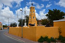
Kralendijk Lighthouse (or Fort Oranje Lighthouse) is an active lighthouse in the town of Kralendijk, Bonaire, in the Caribbean Netherlands. It was built in 1932 on the grounds of Fort Oranje, a 17th century fort.[3][4]
- ^ a b c d Cite error: The named reference
bonairewas invoked but never defined (see the help page). - ^ a b c d List of Lights, Pub. 110: Greenland, The East Coasts of North and South America (Excluding Continental U.S.A. Except the East Coast of Florida) and the West Indies (PDF). List of Lights. United States National Geospatial-Intelligence Agency. 2016. p. 185.
- ^ Rowlett, Russ. "Lighthouses of Bonaire". The Lighthouse Directory. University of North Carolina at Chapel Hill. Retrieved 26 April 2024.
- ^ "Vuurtorens op Bonaire | Beautiful Bonaire". www.beautiful-bonaire.nl (in Dutch). Retrieved 2024-04-27.