Krupa na Uni
Крупа на Уни | |
|---|---|
 | |
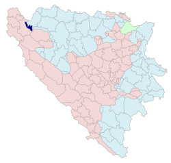
 Location of Krupa na Uni within Bosnia and Herzegovina | |
 | |
| Coordinates: 44°53′N 16°09′E / 44.883°N 16.150°E | |
| Country | |
| Entity | |
| Geographical region | Bosanska Krajina |
| Government | |
| • Municipal mayor | Gojko Kličković (NPS) |
| Area | |
• Total | 84.33 km2 (32.56 sq mi) |
| Population (2013 census) | |
• Total | 1,597 |
| • Density | 19/km2 (49/sq mi) |
| Time zone | UTC+1 (CET) |
| • Summer (DST) | UTC+2 (CEST) |
| Area code | 52 |
| Website | www |
Krupa na Uni (Serbian Cyrillic: Крупа на Уни) is a municipality in Republika Srpska, Bosnia and Herzegovina. It is situated in the northwestern part of Republika Srpska and the central part of the Bosanska Krajina region. The seat of the municipality is the village of Donji Dubovik.


