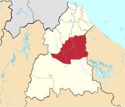
Kuala Krai District
Kkeghe | |
|---|---|
| Jajahan Kuala Krai | |
| Other transcription(s) | |
| • Jawi | كوالا كراي |
| • Chinese | 瓜拉吉赖县 |
| • Tamil | கோலா கிராய் |
 Location of Kuala Krai District in Kelantan | |
 | |
Location of Kuala Krai District in Malaysia | |
| Coordinates: 5°30′N 102°10′E / 5.500°N 102.167°E | |
| Country | |
| State | |
| Seat | Kuala Krai |
| Local area government(s) | Kuala Krai District Council (North Kuala Krai) Dabong District Council (South Kuala Krai) |
| Government | |
| • District officer | Haji Tengku Ab Rahman bin Tuan Yunus[1] |
| • Administrative office | Kuala Krai Land Officers and Colony |
| Area | |
| • Total | 2,275 km2 (878 sq mi) |
| Population (2021)[3] | |
| • Total | 105,900 |
| • Density | 47/km2 (120/sq mi) |
| Time zone | UTC+8 (MST) |
| • Summer (DST) | UTC+8 (Not observed) |
| Postcode | 18xxx |
| Calling code | +6-09-9 |
| Vehicle registration plates | D |

Kuala Krai District is a district (jajahan) in Kelantan, Malaysia. Historically, it was known as Kuala Lebir.[4]
- ^ "Pejabat Tanah Dan Jajahan Kuala Krai - Perutusan Ketua Jajahan". www.ptjkk.kelantan.gov.my. Retrieved 9 September 2022.
- ^ Cite error: The named reference
ptjkkwas invoked but never defined (see the help page). - ^ "Population Distribution and Basic Demographic Characteristics, 2010" (PDF). Department of Statistics, Malaysia. Archived from the original (PDF) on 22 May 2014. Retrieved 19 April 2012.
- ^ "Map of British Malaya Including The Straits Settlements Federated Malay States and Malay States Not Included In The Federation 1924" (JPG). Raremaps.com. Retrieved 26 April 2016.

