Kuala Terengganu | |
|---|---|
| City of Kuala Terengganu Bandaraya Kuala Terengganu | |
| Other transcription(s) | |
| • Jawi | كوالا ترڠڬانو |
| • Chinese | 瓜拉登嘉楼 (Simplified) 瓜拉登嘉樓 (Traditional) Guālā-dēngjiālóu (Hanyu Pinyin) |
| • Tamil | கோலா திராங்கானு Kōlā Tirāṅkāṉu (Transliteration) |
From top, left to right: The Kuala Terengganu skyline, Chinatown, city view from Duyong Island, the Abidin Mosque, and the Syarqiyyah Palace, The Crystal Mosque | |
| Nickname: KT | |
| Motto(s): Bandaraya Warisan Pesisir Air English: Waterfront Heritage City | |
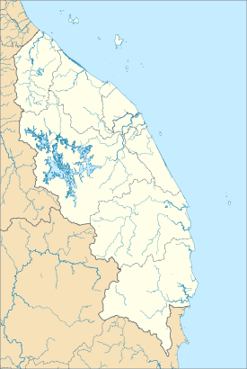
 Location of Kuala Terengganu in Terengganu | |
| Coordinates: 05°19′45″N 103°08′10″E / 5.32917°N 103.13611°E | |
| Country | |
| State | |
| Districts | Kuala Terengganu Kuala Nerus |
| Administrative areas | List |
| Establishment of the local government | 1928 |
| Establishment of the Town Board | 1950 |
| Establishment of the Town Council | 1972 |
| Municipality status | 18 January 1979 |
| City status | 1 January 2008 |
| Government | |
| • Type | City council |
| • Body | Kuala Terengganu City Council |
| • Mayor | Tuan Haji Rosli bin Latif (since 5 June 2022) |
| • MP | Rosol Wahid (Perikatan Nasional) (Hulu Terengganu) (since 9 May 2018) Abdul Hadi Awang (Perikatan Nasional) (Marang) (since 11 March 2008) Ahmad Amzad Hashim (Perikatan Nasional) (Kuala Terengganu) (since 9 May 2018) Alias Razak (Perikatan Nasional) (Kuala Nerus) (since 19 November 2022) Shaharizukirnain Abdul Kadir (Perikatan Nasional) (Setiu) (since 9 May 2018) |
| Area | |
| • Total | 605 km2 (233.59 sq mi) |
| Elevation | 15 m (49 ft) |
| Population (2020)[3] | |
| • Total | 375,424 (1st)[1] |
| • Density | 705/km2 (1,830/sq mi) |
| • Demonym | Kuala Terengganuan |
| Time zone | UTC+8 (MST) |
| • Summer (DST) | Not observed |
| Postal code | 20xxx |
| Area code(s) | 09-6xxxxxxx |
| Vehicle registration | T |
| Website | mbkt |
Kuala Terengganu (Malaysian: [ˈkuˈala ˈtəˈrəŋˈganu]; Terengganu Malay: Kole Tranung), colloquially referred to as KT, is the administrative, economic and royal capital of the state of Terengganu, Malaysia. Kuala Terengganu is also the capital of Kuala Terengganu District. It is also the only royal capital among the nine royal states of the country to bear its state's name. Kuala Terengganu is located about 440 kilometres northeast of Kuala Lumpur on the East Coast of Peninsular Malaysia. The city is situated at the estuary of Terengganu River, facing the South China Sea.
As a district, Kuala Terengganu is the smallest in terms of area, but it and Kuala Nerus District that together form the city area has the largest population in Terengganu. The city population was 406,317 in 2010[1][4] and grew to 375,424 in 2020.[5] City status was awarded to Kuala Terengganu with the title Bandaraya Warisan Pesisir Air (English: Waterfront Heritage City) on 1 January 2008.[6]
Besides being a major political and economic centre to the state, the city is also the main gateway to many of the state's tourist destinations. The attractions in and around the city include Kampung Cina, Pasar Besar Kedai Payang, Terengganu State Museum, and Batu Buruk Beach. Even though the city is not spared from modernity and development, Kuala Terengganu still retains strong Malay influences that are intermixed with other cultures from its long history as a port.[7]
- ^ a b The total population and total area also includes the population and area for the district of Kuala Nerus, which was a part of the district of Kuala Terengganu, but Kuala Nerus is still under the jurisdiction of Kuala Terengganu City Council.
- ^ "Malaysia Elevation Map (Elevation of Kuala Terengganu)". Flood Map : Water Level Elevation Map. Archived from the original on 22 August 2015. Retrieved 22 August 2015.
- ^ "Population Distribution by Local Authority Areas and Mukims, 2010 (page 1 & 8)" (PDF). Department of Statistics, Malaysia. Archived from the original (PDF) on 5 February 2015. Retrieved 19 July 2013.
- ^ "Total Population by Ethnic Group, Sub-district and State, Malaysia, 2010". Kuala Terengganu City Council. Archived from the original on 8 April 2015. Retrieved 22 March 2015.
- ^ "Poket Stats Negeri Terengganu ST3 2020" (PDF). Department of Statistics Malaysia. Archived from the original (PDF) on 7 January 2022. Retrieved 7 January 2021.
- ^ "Background". Kuala Terengganu City Council. Retrieved 27 December 2017.
- ^ David Bowden (9 April 2013). "The East Coast of Malaysia, an Enchanting Encounter". Expat Go Malaysia. Retrieved 25 March 2015.


