Kugluktuk
Qurluqtuq ᖁᕐᓗᖅᑐᖅ | |
|---|---|
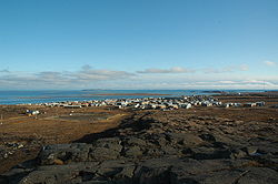
 Hill top view of Kugluktuk | |
| Coordinates: 67°49′36″N 115°05′36″W / 67.82667°N 115.09333°W[1] | |
| Country | Canada |
| Territory | Nunavut |
| Region | Kitikmeot |
| Electoral district | Kugluktuk |
| Government | |
| • Mayor | Ryan Nivingalok |
| • MLA | Bobby Anavilok |
| Area (2021)[4] | |
| • Land | 538.99 km2 (208.11 sq mi) |
| Elevation | 23 m (75 ft) |
| Population (2021)[4] | |
• Total | 1,382 |
| • Density | 2.6/km2 (7/sq mi) |
| • DPL[6] | 956 |
| Time zone | UTC−07:00 (MST) |
| • Summer (DST) | UTC−06:00 (MDT) |
| Canadian Postal code | |
| Area code | 867 |
Kugluktuk (Qurluqtuq, lit. 'the place of moving water';[7] Inuktitut syllabics: ᖁᕐᓗᖅᑐᖅ; Inuktitut pronunciation: [quʁluqtuq]), known as Coppermine until 1 January 1996, is a hamlet at the mouth of the Coppermine River in the Kitikmeot Region of Nunavut, Canada, on Coronation Gulf, southwest of Victoria Island. It is Nunavut's westernmost community, near the border with the Northwest Territories.
The area's traditional language is Inuinnaqtun, which is written in the Latin alphabet, rather than the syllabics of the Inuktitut writing system. Like Cambridge Bay, Bathurst Inlet, and Umingmaktok, syllabics are rarely seen and are used mainly by the Government of Nunavut.
- ^ "Kugluktuk". Geographical Names Data Base. Natural Resources Canada.
- ^ "Hamlet of Kugluktuk". Retrieved 31 December 2022.
- ^ "2021 General Election" (PDF). Elections Nunavut. Retrieved 26 December 2022.
- ^ a b Cite error: The named reference
2021censuswas invoked but never defined (see the help page). - ^ Elevation at airport. Canada Flight Supplement. Effective 0901Z 16 July 2020 to 0901Z 10 September 2020.
- ^ Cite error: The named reference
2021census2was invoked but never defined (see the help page). - ^ "History". Hamlet of Kugluktuk. Retrieved 14 May 2024.

