| Kulunda Кулунда | |
|---|---|
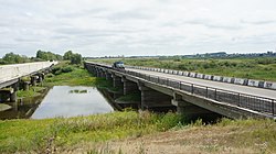
 Bridge over the Kulunda | |
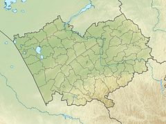
Mouth location in Altai Krai, Russia | |
| Location | |
| Country | Russia |
| Physical characteristics | |
| Source | Ob Plateau |
| • coordinates | 53°18′02″N 82°08′04″E / 53.30056°N 82.13444°E |
| • elevation | ca 200 metres (660 ft) |
| Mouth | Lake Kulunda |
• coordinates | 52°58′52″N 79°43′22″E / 52.98111°N 79.72278°E |
• elevation | 99 metres (325 ft) |
| Length | 412 km (256 mi) |
| Basin size | 12,400 km2 (4,800 sq mi) |
| Discharge | |
| • average | 5.27 m3/s (186 cu ft/s) |
The Kulunda (Russian: Кулунда) is a river in Altai Krai, Russia. The river is 412 kilometres (256 mi) long and has a catchment area of 12,400 square kilometres (4,800 sq mi).[1]
The basin of the river is located in the Rebrikhinsky, Tyumentsevsky, Bayevsky and Blagoveshchensky districts. There are a number of villages near its banks, such as Bayevo, Pokrovka, Kapustinka, Proslaukha and Gryaznovo.[2]
- ^ "Река Кулунда in the State Water Register of Russia". textual.ru (in Russian).
- ^ Google Earth
