 Geography of Kulusuk Island | |
 Location of Kulusuk Island | |
| Geography | |
|---|---|
| Location | North Atlantic |
| Coordinates | 65°33′N 37°07′W / 65.550°N 37.117°W |
| Administration | |
Greenland | |
| Municipality | Sermersooq |
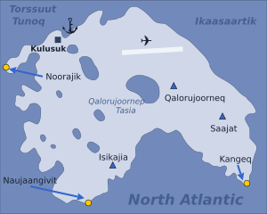
Kulusuk Island (Greenlandic: Kulusup qeqertaa) is an island in the Sermersooq municipality on the southeastern shore of Greenland.[1] It is an outlying island in the Ammassalik archipelago of islands on the coast of the North Atlantic. The island is home to Kulusuk, the fourth-largest settlement on the entire eastern coast of Greenland.[2] The island has an area of 41.98 km2, and measures 8 km (5.0 mi) from north to south and 11 km (6.8 mi) from west to east. The Kulusuk Airport on the island is one of the two airports on the entire eastern Greenland coast.
- ^ Tasiilaq, Saga Map, Tage Schjøtt, 1992
- ^ Statistics Greenland Archived 2011-08-12 at the Wayback Machine (in Danish)